Phone: +88 02 55087611-4 Email: iwm@iwmbd.org webmail Sign In
logo

Design Unit (DGN)

We provide design and planning solutions for IWM.

DGN Unit


The Design Unit (DGN) of IWM plays a crucial role in addressing water management challenges across diverse development sectors, including climate change advocacy, flood management, irrigation management, polder and drainage management systems, and inland waterways development. From planning to the preparation of outline, preliminary, feasibility level design and detailed working designs, the DGN ensures effective intervention strategies.

Specializing in the design and development of critical hydraulic structures, the DGN focuses on water management structures, guide bunds, embankments, and dams, contributing to the sustainable management and preservation of essential water resources. With a commitment to sustainable solutions, the team delivers optimal design solutions by considering hydrological, morphological, and hydraulic parameters. Key areas of expertise include coastal protection, riverbank stabilization, embankment construction, dredging, and flood risk management, inland waterways structures, ancillary building structures and landscaping with utility developments, supported by extensive experience in research, design, and feasibility studies.

AboutUsImg

Services of Design Unit (DGN)

The main services of this Unit are:

1. Flood/ Polder drainage management structure

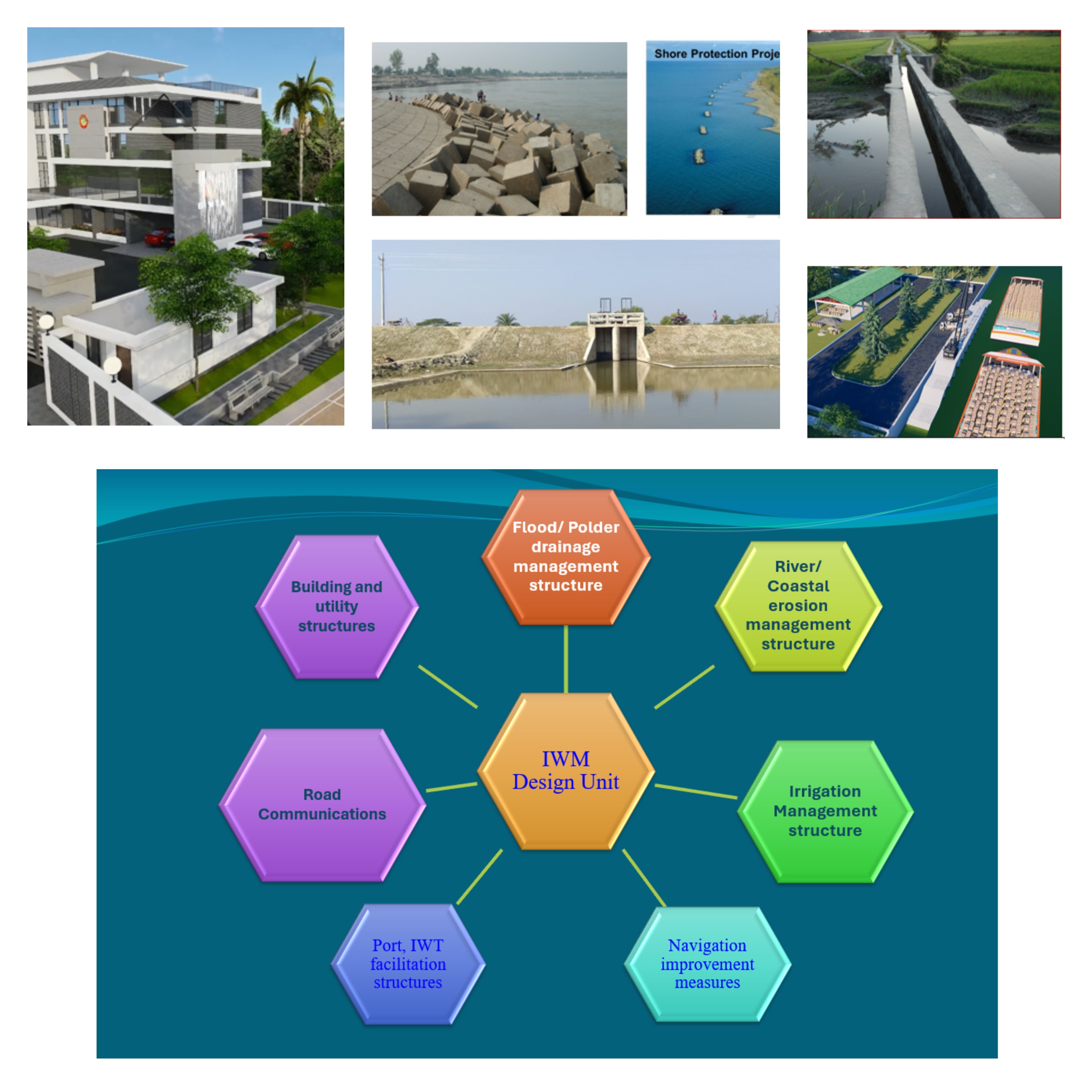
Flood/ Polder drainage management structures in Bangladesh are vital for mitigating the impacts of frequent and severe flooding caused by monsoons, river overflows, and cyclones. Key structures include:

  1. Embankments and Polders: Raised barriers along rivers and coastal areas to prevent inundation, often combined with polders for agricultural protection.
  2. Flood Control Channels: Divert excess water from rivers to reduce flood pressure.
  3. Water Management structure: Upstream and downstream water flow control structure for various reasons.
  4. Retention Ponds: Store excess rainwater to minimize urban flooding.
  5. Drainage Systems: Enhance water flow and reduce waterlogging in low-lying areas.
  6. Dams and Barrages: Control River water levels and regulate flow during peak floods.
  7. Pump Stations: Mechanically drain water from areas where natural flow is insufficient.
  8. Drainage Canals: Facilitate the removal of excess water from within polders to nearby rivers or water bodies.

These systems are integrated with early warning systems and floodplain zoning to enhance disaster preparedness and resilience. Polder drainage management structures in Bangladesh are essential for managing waterlogging and improving agricultural productivity in low-lying coastal and riverine areas. These structures are designed to balance flood control, salinity intrusion prevention, and water availability for agriculture and other uses.


Hydrological and Morphological Model Study for Integrated Water Resources Management and Development of Kutubdia and Matarbari Island. The overall goal of the project is to conduct a comprehensive study for Integrated Development and Water Resources Management of Kutubdia and Matarbari Island, as well as to develop long-term solutions for Water Resources Management that take into account technical, environmental, and social factors. The designed interventions for this project by IWM in 2023 are as follows.

Kutubdia Island (Polder 71)

• Re-sectioning and slope protection works of about 40.18 km embankment.

• Construction of 10 new regulators for the improvement of drainage.

• Re-excavation of 17 khals for drainage purpose to mitigate waterlogging problem and water conservation purpose during dry season.

Matarbari Island (Polder 70

• Re-sectioning and slope protections works of about 17.89 km embankment.

• Construction of 7 new regulators for drainage improvement.

• Re-excavation of 5 khals to enhance drainage.

• Dredging of Kuhelia river, Matarbari Khal and Nunachori Khal which is required for smooth navigation. It also helps drainage of Matarbari polder.

Detailed Study for Restoration and Development of Water Resources Management System of Polder 31 under Dacope Upazila in Khulna District.

The overall objective of this project is to conduct a holistic and integrated study in devising a long-term plan for restoration and development of water resource management system of Polder 31. The designed interventions for this project by IWM in 2024 are as follows.

• 48 km of embankment design around the polder as well as Bank and Slope protection works of about 21.82 km.

• Construction of 23 drainage and flushing regulators, 3 drainage outlets and 7 inlets for drainage, irrigation, fisheries and domestic purpose.

• Re-excavation of 61 khals for drainage improvement and to mitigate waterlogging problem.

  • Purpose of Drainage/Flushing Sluice: A drainage sluice basically effects drainage of a catchment through it by gravity. It prevents entry of outside flood during monsoon when the boundary river is in high stage. It acts to retain water in post-monsoon for supplementary irrigation of transplanted aman crop. During monsoon if there is drought, it may be used for flushing water from outside to inside for the purpose of irrigation and fisheries. In coastal tidal areas, a drainage regulator is used as a flushing gate too for shrimp culture.

ServiceImage

2. River/ Coastal erosion management structure

River and coastal erosion management structures in Bangladesh are critical for protecting vulnerable areas from land loss and preserving livelihoods. Key structures include:

  1. Embankments: Raised barriers to safeguard riverbanks and coastal areas from erosion and flooding.
  2. River Training Works: Guide river flow using spurs, groynes, or revetments to prevent bank scouring.
  3. Coastal protections, Seawalls and Dykes: Solid barriers to protect coastal regions from wave action and tidal erosion.
  4. Geo-Bags and Gabions: Flexible structures filled with sand or stones to stabilize eroding banks.
  5. Mangrove Plantation: A natural solution to mitigate coastal erosion by dissipating wave energy and binding soil.

These measures are vital for long-term resilience against erosion caused by dynamic rivers and rising sea levels.

ServiceImage

3. Irrigation Management structure

Irrigation management structures in Bangladesh are essential for ensuring efficient water distribution and enhancing agricultural productivity. Key structures include:

  1. Canals and Distributaries: Transport of water from rivers or reservoirs to agricultural fields.
  2. Weirs and Rubber dams: Control River water levels and divert flows into irrigation channels.
  3. Pump Stations: Lift water from rivers, reservoirs, or groundwater sources for irrigation in higher elevation areas.
  4. Head Regulators: Manage water flow into main canals and distributaries.
  5. Cross-Regulators: It controls the supply of parental canal i.e. helps in heading up water on u/s and to feed the off-take channel to full demand as and when required.
  6. Check Dams: Store and regulate water in small rivers or streams for irrigation during dry seasons
  7. Syphon: It is a cross-drainage structures to bypass the irrigation canal below a natural drainage canal.
  8. Escape: An escape is a device/structure that is constructed to release excess water from an irrigation canal into a natural drain to prevent flooding and damage of the irrigation canal.
  9. Field Channels: Distribute water from main canals to individual fields efficiently.

These structures ensure equitable water distribution, minimize wastage, and support sustainable agriculture in diverse regions.

ServiceImage

4. Navigation improvement measures

Navigation improvement measures in Bangladesh focus on enhancing the efficiency and safety of inland waterways, which are vital for transportation and trade. Key measures include:

  1. Dredging: Regular maintenance to deepen and widen navigation channels, ensuring adequate water depth for vessels.
  2. River Training Works: Construction of spurs, guide bunds, and revetments to stabilize riverbanks and maintain navigable routes.
  3. Hydrographic Surveys: Continuous monitoring of river depths and flow patterns to inform navigation planning.
  4. Lock and Barrage Systems: Regulate water levels to facilitate smooth vessel movement in variable river conditions.

These measures ensure safe, efficient, and sustainable inland water transport across Bangladesh's extensive river network.

ServiceImage

5. Port, IWT facilitation structures

Port and Inland Water Transport (IWT) facilitation structures in Bangladesh are critical for supporting trade, transportation, and economic development. Key structures include:

  1. River Ports and Jetties: Serve as loading and unloading points for goods and passengers.
  2. Navigation Channels: Maintained through dredging to ensure smooth vessel movement.
  3. Terminals and Cargo Handling Facilities: Equipped for efficient storage and transfer of goods.
  4. Breakwaters: Protect port areas from wave action and sedimentation.
  5. Slipways and Dry Docks: Facilitate vessel repair and maintenance.

These structures enhance connectivity, promote efficient inland waterway transport, and boost the country’s logistics and trade infrastructure.

ServiceImage

6. Road Communications

Road connectivity and building structures in Bangladesh are essential for enhancing transportation networks and supporting urban and rural development. Key components include:

  1. Highways and Bridges: Major roadways and river-spanning structures that connect regions and improve trade routes.
  2. Rural Roads: Local roads linking villages to towns, promoting access to markets and services.
  3. Culverts: Allow water passage under roads, ensuring road durability and preventing flooding.
  4. Bridges: Engineering structures for connecting roadways and facilitating transportation across rivers.
  5. Multi-story Buildings: Serve as hubs for residential, commercial, and institutional activities in growing cities.
  6. Toll Plazas: Manage road access and collect fees for highway maintenance and development.

These infrastructures contribute to improved mobility, economic growth, and overall national development.

ServiceImage

7. Building and utility structures

Building structures in Bangladesh are diverse, supporting residential, commercial, industrial, and institutional needs. Key types include:

  1. Institutional Buildings: Schools, government offices, and cultural centers serving public needs.
  2. Commercial Buildings: Office towers, and retail spaces for businesses and services.
  3. Urban Infrastructure: Public spaces, parks, and recreational facilities enhancing the quality of life in urban areas.
  4. Walkways, Eco parks: This is necessary for the landscaping of an area with proper management. 

These structures are vital for supporting Bangladesh's rapid urbanization and economic development.


ServiceImage

CORE TEAM: DGN Unit


Md. Harun Ur Rasheed

Head, Design Design Unit (DGN)

Email: hur@iwmbd.org

Mobile:

Md. Nazibur Rahman

Senior Water Resources Specialist Design Unit (DGN)

Email: nzr@iwmbd.org

Mobile: 01711134034

Md. Taneem Sarwar

Senior Design Engineer Design Unit (DGN)

Email: mts@iwmbd.org

Mobile:

Barira Khandaker

Junior Engineer Design Unit (DGN)

Email: brr@iwmbd.org

Mobile: 01725004951

Fariha Lara

Junior Engineer Design Unit (DGN)

Email: lra@iwmbd.org

Mobile: 01552356732

Mahira Tasnim

Junior Design Engineer Design Unit (DGN)

Email: trm@iwmbd.org

Mobile: 01619504156

Adiba Afnan

Junior Engineer Design Unit (DGN)

Email: afn@iwmbd.org

Mobile: 01768516435

Nafisa Anjum

Junior Engineer Design Unit (DGN)

Email: anj@iwmbd.org

Mobile: 01686196755

Maisha Ferdousi

Junior Engineer Design Unit (DGN)

Email: mfd@iwmbd.org

Mobile: 01558002221

Tausif Ibn Jakir

Junior Engineer Design Unit (DGN)

Email: tij@iwmbd.org

Mobile: 01535122196

Md. Rocky Babu

Drafting Engineer Design Unit (DGN)

Email: brm@iwmbd.org

Mobile: 01713647317

Moh Shah Jalal

Drafting Engineer Design Unit (DGN)

Email: sja@iwmbd.org

Mobile: 01757782500