ICT, GIS & Remote Sensing Division (ICT)
We develop digital twin of physical system for Smart-solutions

We develop digital twin of physical system for Smart-solutions
We deliver ICT solutions that empower organizations and projects across various stages. Our services modernize planning, implementation, management, operation, and monitoring activities. We leverage GIS, databases, remote sensing, and internet-based technologies, including smart web and mobile applications, to create cutting-edge smart solutions.

We offer a comprehensive suite of services that leverage Geographic Information Systems (GIS), Remote Sensing (RS), and satellite data to provide intelligent solutions for smart planning and monitoring across a wide range of applications.

We leverages our expertise in Information and Communication Technologies (ICT) and software development to create intelligent solutions for a variety of applications. Here's a breakdown of the areas where we can assist clients:

We leverage advanced technologies to implement Smart Data Capture systems, enabling us to collect and manage vital information across various sectors. Our capabilities include:
These features allow us to gather crucial information for applications in agriculture, flood management, land-use planning, river erosion control, and smart city initiatives.

This division boasts a successful track record in delivering large-scale ICT, GIS, and Remote Sensing projects across Bangladesh and internationally. Here are some of our noteworthy milestones:
Crop zoning refers to the specific regions/areas of potential crop and cropping sequences which are biophysically suitable and also have high productivity. Potential crop zones have similar geographic setting in terms of soils, landforms, rainfall, temperature, length of growing period, irrigation potentials. Actually, crop zoning facilitates better utilization of land and water resources thus providing opportunities to harvest full potential of the crops if grown in areas specified as suitable, which in turn derive maximum economic benefit.
The crop zoning can be conceptualized in the context of optimizing crop production through judicious use of land and water resources. Prevent degradation of the environment and to maintain in such a way that the resources of the environment are put to their most beneficial and optimum use while at the same time conserving them for the future. The purpose of crop zoning is to make best and sustainable use of scarce land and water resources for crop production. Crop zoning is particularly supportive for the decision making process concerning land use planning.
Three items are developed under this project:
Khamari Mobile App
Khamari is an effective mobile app suitable for use by farmers and other beneficiaries from agriculture sector of Bangladesh. Through these apps, the farmer will be able to know the most suitable crop for his land according to soil parameters, the crop season and climate parametrs. The Khamari App also provide crop based fertilizer recommendation according to the fertility of the soil, crop variety, yield and life span and required crop seed quantity. It also generate Upazila based suitable crop area, crop layout and crop production technologies.

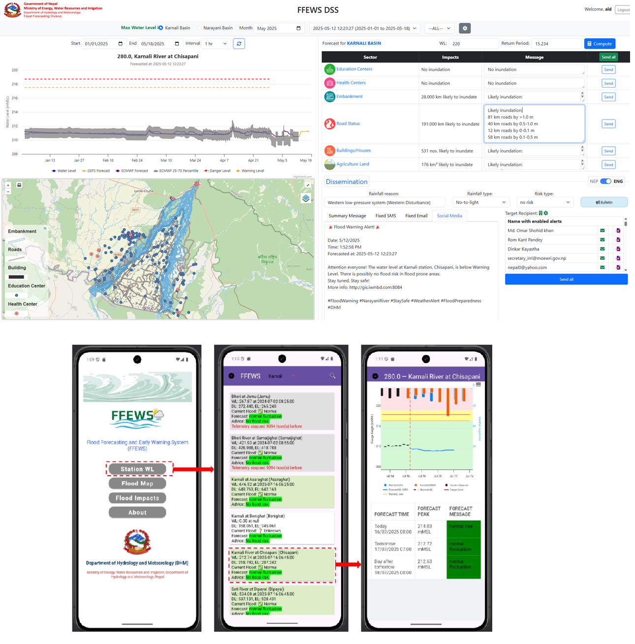
The Flood Forecasting and Early Warning System (FFEWS) is a critical national initiative for the Department of Hydrology and Meteorology (DHM), Government of Nepal, aimed at enhancing flood resilience, particularly for the high-risk Karnali and Narayani River Basins. This project, developed in partnership with Nepalese firms, transitions from traditional experience-based forecasting to an advanced, model-based, and fully automated system.
The system establishes a robust, accurate, and impact-oriented flood forecasting framework capable of real-time data processing and extended lead-time forecasts. Key components include:

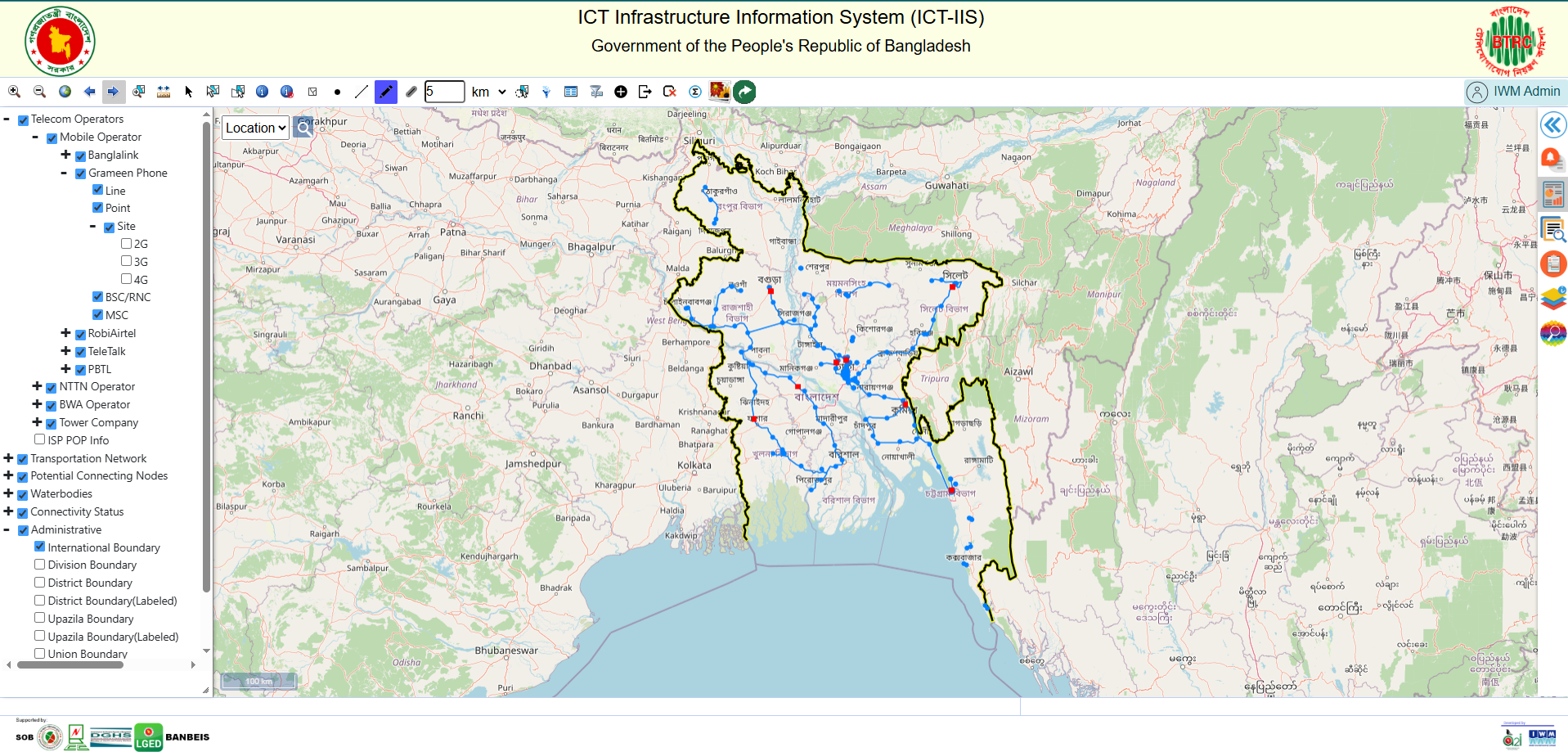
BTRC engaged IWM to prepare a GIS based online system to visualize the fiber optic networks operated by different agencies with aim to better implement their regulatory activities. The providers (Airtel, BCC, Banglalink, Bangladesh Railway, Fiber at Home, Grameen, Citycell, PGCB, RobiAxiata, Summit Communication and Airtel) provided the processed data in specified format. The data were mainly Fiber Optic Lines and Node Points both having several attributes.
The overall objective is to develop a GIS based interactive web application for National Network considering scalability and interoperability using Open Source development tools.
The specific objectives are:

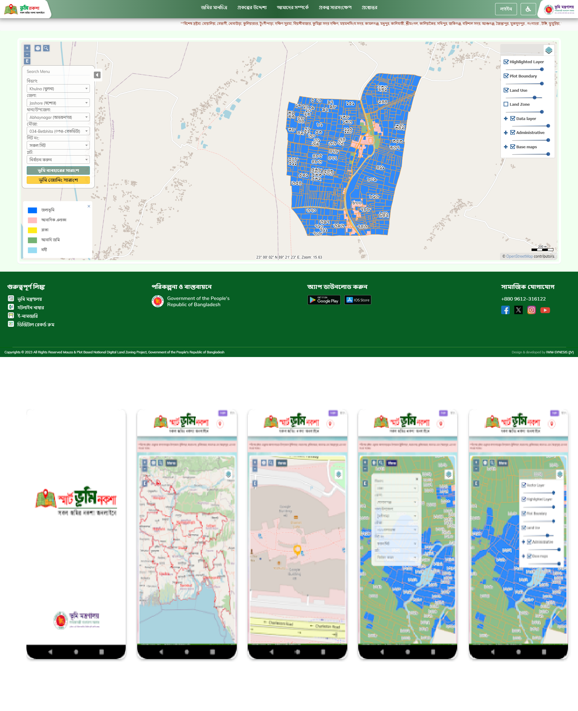
This project represents a revolutionary reform by the Ministry of Land, Government of Bangladesh, through the implementation of a comprehensive digitalization strategy to streamline and enhance land management services. The primary goal is to provide citizen-friendly services and ensure the highest quality utilization of land.
The initiative introduced land zoning as a crucial tool for the government to plan and allocate land based on optimal use, while considering socioeconomic and environmental factors. A key deliverable is a web-based platform that provides all interested users with an attractive overview of land zoning and detailed information about land use within mouzas (administrative units) and specific plots.
The digital platform empowers citizens to:
The system supports multiple user roles (Administrative, Management, Data Entry Operator, Public User/Citizens, and Government Ministry) and includes robust modules for:

An Interactive Database System for Research, Monitoring, and Analyses of Bangladesh Coastal Zone towards long term sustainable polder development and management with attention to geo-morphological, environmental, economic and ecological aspects. The database will help in longtime monitoring of polder situation after any project intervention, which include:

The Ministry of Water Resources of the Government of the People’s Republic of Bangladesh decreed the Participatory Water Management (PWM) Rules 2014 through a gazette notification on February 11, 2014. The rules relate to the formation and functions of water management organizations (WMOs) in water resources projects. The most important shift suggested by the PWM Rules 2014 is that the WMOs will be registered under the Bangladesh Water Development Board (BWDB) rather than the Department of Cooperatives (DoC). The Rules emphasize the larger enrollment of local stakeholders in the water management groups (WMGs) and their participation in the operation and maintenance (O&M) of the water management infrastructure. The project amimed to implement a web-enabled Geographical Information System (GIS) based management information system (MIS) that will enable the project as well as BWDB to make planning, monitoring, and maintenance of project works along with contractors and vendors management. It will also integrate existing MIS modules like project information, WMO management, O&M budgeting, progress monitoring, document management, structure information, GIS mapping, etc.
The web based PPMIS application provides:

The project employs a comprehensive approach to scale up action and address the challenges described in the previous sections to: (i) increase the cover, improve quality and management of natural forests and biodiversity and coastal ‘green belt’ through collaboration with communities; (ii) improve living standards through alternative income generation options to forest dependent communities; and, (iii) BFD 4 Bangladesh Sustainable Forest and Livelihood Project improve the policy and regulatory environment to enhance tree planting on private lands. The project will be implemented in selected sites in 147 Upazilas/sub-districts of 28 districts.

Revolution of the Information and Communication Technology (ICT) thrusted positively in governance, policy and planning, and decision-making process in government and private sectors in all over the world. In line with national vision 2021, Bangladesh Water Development Board (BWDB) has taken an epoch-making step to develop Smart ICT system for managing and monitoring of BWDB Scheme information. BWDB assigned this task to IWM under a contract initially for developing for South-Eastern Zone technically starting from the existing SIMS (Scheme Information Management System) developed under WAMIP. The developed System is named SiMS-Smart, meaning Scheme Information Management System with Smart Technologies.
The overall objective of the SiMS-Smart is to support BWDB officials in planning, budgeting, estimating monitoring the rehabilitation/improvement works and O&M of all types of projects or Schemes. The SiMS-Smart extends its capabilities by utilizing Smart devices (Mobile, Tablets), IP-Camera, Skype, SMS integrated with web GIS and Oracle database.
SiMS-Smart is a long step of BWDB towards national vision 2021 – “Digital Bangladesh.

UNDP took the initiative to develop a Hazard Risk Profile for the industry sectors of Bangladesh facing certain common and frequent disaster threats (i.e., floods, cyclones and tidal surges, drainage/water logging, salinity, earthquake and fires) under its National Resilience Program (NRP). The developed Risk Profile will provide industrialist, decision makers and authorities an effective planning approach to minimize the losses and damages due to the impact of Climate change and natural disasters.
The spatial data of this study included, among others, the industrial structure footprints, land use, topography, roads, rivers, canals, cyclone tracks, satellite images, and fire stations, while the non-spatial data included hydro-meteorological data of historical time series like water level, water discharge, salinity intrusion in the Karnaphuli river system, rainfall data, and related hazards such as water logging, fire incidences, and COVID-19.
Based on the results of the study’s model simulation, the exposure, vulnerability and risk profiles have been developed for the mentioned hazards in the industries of the two study areas in the form of GIS maps and tables. The hazard risk profiles will provide an overview of probable risks related to floods, cyclones and tidal surges, water logging/drainage, salinity, earthquakes, fire incidences, as well as COVID-19.

Department of Bangladesh Haor and Wetland Development (DBHWD) has developed Haor Master Plan with a view to protect, preserve and conserve the haor wetlands from degradation as well as for sustainable management of wetlands. The study project has been formulated with a view to establish a national wetland inventory and wetland management framework emphasizing interaction between haor and river ecosystem to identify wetlands all over the country, to formulate national wetland policy, for identifying wetland suitable for restoration, to reserve and conserve biodiversity of wetland areas, to assess its status and trends considering climate variability, impact as well as for sustainable wetland management.. This study delineated and classified the wetlands for establishment of inventory and identifications of interaction between haor and river ecosystem.
The main objective is to prepare an inventory of the wetlands and assess the best wetland management practices for developing a cluster-wise national wetland management framework.
This study identified water bodies from satellite images having an area greater than 5 hactors according to hydrological region of Bangladesh. Also a comprehensive wetland inventory based on geo-morphological data, physiographic features, flora and fauna species and hydrological features for the selected wetland. The connectivity and interactions between wetland and river ecosystems will be identified by comparing of water level. The causes of wetland degradation and sources of pollution for the selected wetland will also be determined through field survey campaign.

Our Team is composed of experts in the fields of ICT-Solutions, GIS, Remote Sensing and Database development

Email: hmk@iwmbd.org
Mobile: 01712-754211
Email: mmm@iwmbd.org
Mobile: 01841930077
Email: zhs@iwmbd.org
Mobile: 01841930094
Email: mkz@iwmbd.org
Mobile: 01783 666 415
Email: ruh@iwmbd.org
Mobile: 01738657164
Email: mya@iwmbd.org
Mobile: +880 1556 309 606
Email: fer@iwmbd.org
Mobile: +880 1991 307 026
Email: bnt@iwmbd.org
Mobile: +880 1306 339 157

Email: rzr@iwmbd.org
Mobile: 01810-107229, 01930-515730
Phone: 880-2-55087611-4